Hurdal
Hurdal Municipality
Hurdal kommune | |
|---|---|
|
| |
 Akershus within Norway | |
 Hurdal within Akershus | |
| Coordinates: 60°24′57″N 11°0′31″E / 60.41583°N 11.00861°E | |
| Country | Norway |
| County | Akershus |
| District | Romerike |
| Administrative centre | Hurdal |
| Government | |
| • Mayor (2013) | Runar Bålsrud (V) |
| Area | |
• Total | 285 km2 (110 sq mi) |
| • Land | 261 km2 (101 sq mi) |
| • Rank | #284 in Norway |
| Population (2004) | |
• Total | 2,679 |
| • Rank | #292 in Norway |
| • Density | 10/km2 (30/sq mi) |
| • Change (10 years) | |
| Demonym(s) | Hurdaling or Hurdøling[1] |
| Official language | |
| • Norwegian form | Bokmål |
| Time zone | UTC+01:00 (CET) |
| • Summer (DST) | UTC+02:00 (CEST) |
| ISO 3166 code | NO-3242[3] |
| Website | Official website |
Hurdal is a municipality in Akershus county, Norway. It is part of the traditional region of Romerike. The administrative centre of the municipality is the village of Hurdal.
Hurdal is located about 70 kilometres (40 mi) north of Oslo, along the lake Hurdalsjøen. Fjellsjøkampen is the highest hill in Akershus. The mountains Faksebrennkollene and Toppåsen are also located in the municipality.
General information
[edit]Name
[edit]The name (Old Norse: Urðardalr and Hurðardalr) is an old district name. (The name of the church site is Gjøing.) The first element is the genitive case of an old river name (later called Gjøingelva which means "Gjøing river"), probably Urð which means "stony river" (from urð which means "scree"). (The sideform Hurðardalr has an addition of a false /h/.) The last element is dalr meaning "valley" or "dale". Prior to 1918, the name was spelled "Hurdalen".
Coat-of-arms
[edit]The coat-of-arms is from modern times. They were granted in 1988. The arms are green with a yellow-colored cone from a Norway Spruce tree (Picea abies).[4]
| Ancestry | Number |
|---|---|
| 28 | |
| 27 | |
| 27 |
History
[edit]The parish of Hurdalen was established as a municipality on 1 January 1838 (see formannskapsdistrikt). The new municipality of Feiring was separated from Hurdal on 1 January 1870.
Attractions
[edit]- Holy Trifon Skete, an Eastern Orthodox monastery of Orthodox church in Norway (Saint Nicolas commune). The monastery was established in 1985.[6]
Notable residents
[edit]- Børre Rognlien (born 1944 in Hurdal) a sports official and politician, former journalist and military officer
- Harald Sunde (born 1954 in Hurdal) a military officer, head of the Norwegian Armed Forces 2009 to 2013
- Robert Sørlie (born 1958 in Hurdal) - dog sled racer, winner of Iditarod Trail Sled Dog Race in 2003 and 2005
- Kjetil Mulelid (born 1991 in Hurdal) a Norwegian jazz pianist and composer
Gallery
[edit]-
Suburbant boligfelt i Hurdal
-
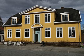
Kirkekretsen skole i Hurdal, kafè
-
Naturstien ved Buråstjernet i Hurdal
-
Hurdal rådhus
References
[edit]- ^ "Navn på steder og personer: Innbyggjarnamn" (in Norwegian). Språkrådet.
- ^ "Forskrift om målvedtak i kommunar og fylkeskommunar" (in Norwegian). Lovdata.no.
- ^ Bolstad, Erik; Thorsnæs, Geir, eds. (2024-01-09). "Kommunenummer". Store norske leksikon (in Norwegian). Foreningen Store norske leksikon.
- ^ "Kommunevåpen" (in Norwegian). Hurdal kommune. Retrieved 2008-12-20.
- ^ "Immigrants and Norwegian-born to immigrant parents, by immigration category, country background and percentages of the population". ssb.no. Archived from the original on 2 July 2015. Retrieved 29 June 2015.
- ^ Russian flag in Norwegian monastery Archived 2011-07-24 at the Wayback Machine. Tidsskrift for Russisktalende i Norge Landsmann (Bergen). (in Russian)
External links
[edit] Media related to Hurdal at Wikimedia Commons
 The dictionary definition of Hurdal at Wiktionary
 Akershus travel guide from Wikivoyage
- Municipal fact sheet from Statistics Norway


